Google maps have allowed me a peek at the homes i used to reside in.
20 Short Street Moe
View Larger Map
Woods point Road Warburton
View Larger Map
Warburton-Woods Point road Matlock
View Larger Map
Herbert Ave East Warburton
View Larger Map
Riverside Drive East Warburton
View Larger Map
27 Cavanaugh Road Millgrove Vic
View Larger Map
Balaclava
View Larger Map
88 Wellington Street Windsor
View Larger Map
5 Hume Street Huntingdale
View Larger Map
6-241 Nicholson St Abbotsford
View Larger Map
6 Bielby Street Tugun
View Larger Map
Brisbane Road Labrador
View Larger Map
14 Kardella Street Ashmore
View Larger Map
Hansford road Coombabah
View Larger Map
55 Hansford Road Coombabah
View Larger Map
35 Wongawallan Drive Upper Coomera
View Larger Map
11 Seaton Court Nerang
View Larger Map
55 Pimpama Road Jacobs Well
View Larger Map
Thursday, July 30, 2009
Sunday, July 26, 2009
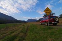
Condamine Gorge
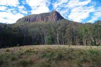
At the start of the longest continuous river system in Australia, the Condamine River has carved its way from Mt Superbus through the towering peaks of the Main Range National Park in the Great Dividing Range on its 3000 odd Kilometre journey to become the Balonne, Darling and Murrey Rivers before emptying itself into the Ocean at Coorong in South Australia.
The Bicentennial National Trail cuts through the Condamine Gorge between Killarney and Moogerah, we chose to follow this track from Killarney to the Head then turn sharp right and follow Spring Creek road back to Queen Mary Falls before ending back near Killarney.
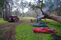
At only around 50 Km long, this loop can be done in a day or weekend depending on how much exploring you do of the numerous attractions along the way, there are a number of Bed and Breakfasts, Caravan Parks and Motels in the area but we chose to camp opposite the old hut part way in before starting the main drive the next morning.
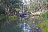
With the river meandering past a few metres away, the area was a nice place to camp although there are no facilities of any sort and the stinging nettles are prolific, care should be taken with young children or you may end up with a ruined weekend.
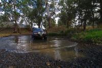
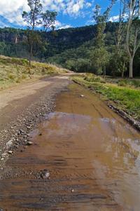
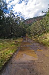
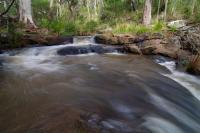
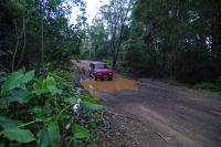
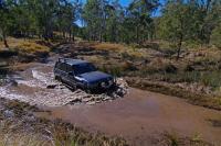
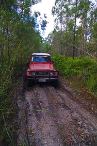
With over a dozen river crossings the Condamine Gorge track is very dependant on water levels and rainfall and is suitable for soft roaders with the deepest crossing being around 300mm when we went through, if you get through the first one you should be fine for all the rest as they were only around 100mm deeper.
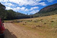
Leaving Killarney we headed towards Legume for about 3 Kms then turned left into Brosnans road where the bitumen turned to dirt as the gap between the hills became evident, the first river crossing was soon upon us as we started to criss cross the river due the steep sides of the hills crowding in on the track.
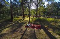
After a few crossings we spied an old hut on the right and pulled up to make camp on the banks of the river straight opposite while we had enough light to collect some wood to guard against the evening chill.
A tree had fallen over but continued to grow making a fairly unique back drop to the existing campfire so we cleaned up the area a little and settled down to enjoy the tranquillity with the only noise being the crackling of the campfire and the rustle of the birds as they searched for their evening meal.
The steep sided gorge prevents the morning sun hitting the campsite until late but it was nice to lay in the swag watching the suns rays light up the cliffs behind the old hut.
When underway again, the Rocky crossing near the campsite was taken slowly as the bottom is rough unless you take the correct line.
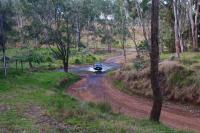
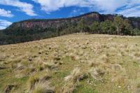
The towering cliffs come into uninterrupted view as you turn the corner and are soon hidden again as you plunge into the trees on yet another crossing.
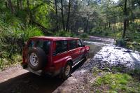
When we arrived at the deepest crossing of them all, we took the opportunity to wash the sand and salt from the previous weekends beach run with a quicker run over the smooth gravel base.
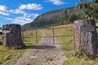
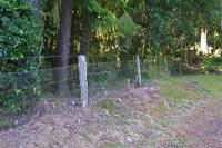
Just after you pass the distinctive gate with its tree trunk posts on the right hand side you get another clear view of the cliffs before you round the corner to a wet section of track which has been repaired using corduroy, the laying of logs side by side to make a solid foundation.
It isn't long until we exit the gorge and reach "The Head" where we turn hard right on to Spring Creek Road and head nearly back the way we came with views back down over the Gorge from higher up.
As we climb, the road turns back to bitumen and passes a section of the 5614 kilometre long Wild Dog Fence, the fence originally built to keep rabbits out of South Australia, the fence is now maintained to prevent Dingoes entering sheep grazing areas and runs from Jimbour in Queensland to the Great Australian Bight in South Australia.
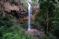
The road travels past several great views of the valleys and hills until it reaches the 40 metre high Queen Mary Falls.
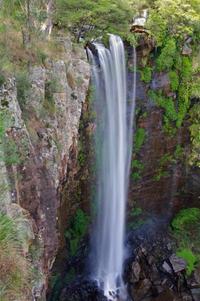
You can cross Spring creek to get to the lookout on the other side and a walking track also winds its way down to the base of the falls before winding its way back to the top again.
The picnic area at the top of the falls is a popular place with disabled toilets available and a shop and caravan park across the road.

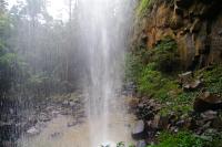
Further down the creek is Daggs Falls with a lookout from beside the road but no walking trails.
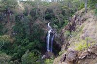
As you reach the bottom of the hills another picnic area at Browns Falls give access to the rugged walk along the creek to the spectacular Browns Falls, This scramble over slippery rocks is not suitable for anyone but the able bodied as there is no formed tracks at all but is well worth the struggle to get there.
A few kilometres later you are back near Killarney again only 1 kilometre from where you started having passed through some rugged spectacular gorges and cool rainforest with magnificent views from both beneath and above towering cliffs.
The Bicentennial National Trail cuts through the Condamine Gorge between Killarney and Moogerah, we chose to follow this track from Killarney to the Head then turn sharp right and follow Spring Creek road back to Queen Mary Falls before ending back near Killarney.
At only around 50 Km long, this loop can be done in a day or weekend depending on how much exploring you do of the numerous attractions along the way, there are a number of Bed and Breakfasts, Caravan Parks and Motels in the area but we chose to camp opposite the old hut part way in before starting the main drive the next morning.
With the river meandering past a few metres away, the area was a nice place to camp although there are no facilities of any sort and the stinging nettles are prolific, care should be taken with young children or you may end up with a ruined weekend.
With over a dozen river crossings the Condamine Gorge track is very dependant on water levels and rainfall and is suitable for soft roaders with the deepest crossing being around 300mm when we went through, if you get through the first one you should be fine for all the rest as they were only around 100mm deeper.
Leaving Killarney we headed towards Legume for about 3 Kms then turned left into Brosnans road where the bitumen turned to dirt as the gap between the hills became evident, the first river crossing was soon upon us as we started to criss cross the river due the steep sides of the hills crowding in on the track.

After a few crossings we spied an old hut on the right and pulled up to make camp on the banks of the river straight opposite while we had enough light to collect some wood to guard against the evening chill.


A tree had fallen over but continued to grow making a fairly unique back drop to the existing campfire so we cleaned up the area a little and settled down to enjoy the tranquillity with the only noise being the crackling of the campfire and the rustle of the birds as they searched for their evening meal.

The steep sided gorge prevents the morning sun hitting the campsite until late but it was nice to lay in the swag watching the suns rays light up the cliffs behind the old hut.

When underway again, the Rocky crossing near the campsite was taken slowly as the bottom is rough unless you take the correct line.

The towering cliffs come into uninterrupted view as you turn the corner and are soon hidden again as you plunge into the trees on yet another crossing.


When we arrived at the deepest crossing of them all, we took the opportunity to wash the sand and salt from the previous weekends beach run with a quicker run over the smooth gravel base.

Just after you pass the distinctive gate with its tree trunk posts on the right hand side you get another clear view of the cliffs before you round the corner to a wet section of track which has been repaired using corduroy, the laying of logs side by side to make a solid foundation.


It isn't long until we exit the gorge and reach "The Head" where we turn hard right on to Spring Creek Road and head nearly back the way we came with views back down over the Gorge from higher up.


As we climb, the road turns back to bitumen and passes a section of the 5614 kilometre long Wild Dog Fence, the fence originally built to keep rabbits out of South Australia, the fence is now maintained to prevent Dingoes entering sheep grazing areas and runs from Jimbour in Queensland to the Great Australian Bight in South Australia.

The road travels past several great views of the valleys and hills until it reaches the 40 metre high Queen Mary Falls.

You can cross Spring creek to get to the lookout on the other side and a walking track also winds its way down to the base of the falls before winding its way back to the top again.

The picnic area at the top of the falls is a popular place with disabled toilets available and a shop and caravan park across the road.

Further down the creek is Daggs Falls with a lookout from beside the road but no walking trails.

As you reach the bottom of the hills another picnic area at Browns Falls give access to the rugged walk along the creek to the spectacular Browns Falls, This scramble over slippery rocks is not suitable for anyone but the able bodied as there is no formed tracks at all but is well worth the struggle to get there.


A few kilometres later you are back near Killarney again only 1 kilometre from where you started having passed through some rugged spectacular gorges and cool rainforest with magnificent views from both beneath and above towering cliffs.
Saturday, July 25, 2009
Spicers Gap
Only two hours south west of Brisbane lies the rugged Main Range National Park and its steep and torturous highway climbing up through Cunninghams Gap just east of the small village of Aratula.
This Highway was not the original route to the Darling Downs though, the earlier route was discovered by stockman Henry Alphen in 1847 and the subsequent road up through Spicer Gap was built in the late 1850’s, its here we get the chance to get the wheels a little dirty and take in some of the serenity and fantastic scenery of the area.
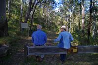
National Parks have closed the central portion of the road to vehicles but access is still available to both ends and you can walk the closed section.
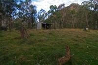
A day use area and Campground is available opposite the site of the old tavern.
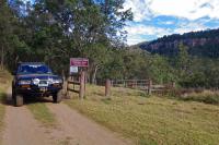
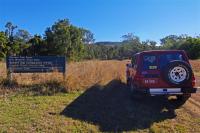
To access the Spicers Gap section head east on the highway from Aratula for 5 Km and turn left then after a further 5.7 Km turn right and follow this road for 3 Km until the road turns to gravel, it is suitable for all vehicle types although the steep gravel section could be a problem in a front wheel drive and 4wd would be needed in wet weather.
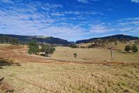
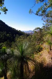
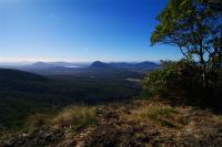
2.6 Km later an unmarked lookout on the right is worth stopping for a look as it affords a view over grasstrees to the hills in the distance.
The park boundary comes up a short time later and 1.4 Kms after the lookout we turn left into the picnic area just after the campground entrance.
Although Fires are not allowed in the campground they supply wood fired BBQ’s in the picnic area next door, seems a little strange!
A disabled access toilet sits between the two.
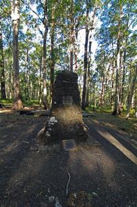
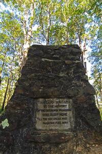
A short walk leads to the memorial of the 13 unmarked graves in the unmarked cemetery, the writing seems to have been done by what appears to be carpet tacks or similar imbedded in the concrete.
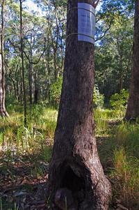
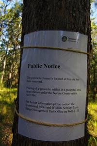
We noticed something white on a hollow tree not far away but upon investigation turned out to be a sign saying “no Geocacheing allowed” … I think I would prefer to “not” see a Geocache hidden in the hollow of a tree than a big national parks sign saying this is where it used to be until it was removed.
Across the road an orchard has been built on the site of the old tavern but we could not see any old relics from the roadway so we had a look around the campground instead, it does not look well used so should be a fairly quiet and tranquil spot to make camp although the usual National Park bollards make it hard for vehicle based camping.
Mount Mathieson is spelt three different ways by National Parks on signs and pamphlets , Mount Matherson, Mount Matheson and Mount Mathieson but as there is a Mount Matheson in Nightcap national park we can probably discount that one.
The Chief Commissioner of railways was a man named John Mathieson and the nearby peak was apparently named after him so that is the most likely spelling.
The Mount Mathieson Walking track heads past the orchard opposite the campground finishing at the western end of the closed section of road.
The eastern end of the closed road at Governors chair is only 2 Kms away by gravel road.
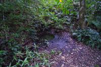
We drove on crossing a deep puddle and stopped for a look at Moss’s Well, a round concrete ring full of fresh water supplied by a nearby spring.
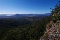
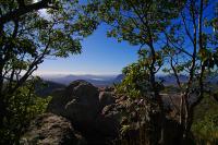
We continued on and it wasn’t long before we reached the carpark and picnic table at Governors Chair where we walked the 150 metres up the stairs to the lookout with spectacular views over the surrounding countryside.
“Governors Rock” as it was first called was named after Governor-General Sir Charles Fitzroy in 1854, perhaps the U shaped rock inspired the name change to Governors Chair?
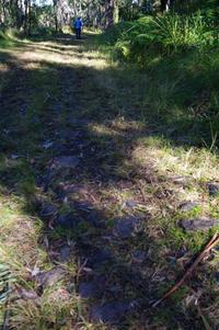
The 1.6 Km closed off section of road begins across the other side of the carpark and has interpretive signs dotted along the way explaining some of the roads construction methods such as Corduroy and Stone Pitching.
The diversionary embankments used to divert water across the road probably get their name from the term “Whoaboy” used by the bullock drivers when approaching these banks.
After our walk we decided to explore the western end of the Spicers Gap road and made our way back to the Cunningham Highway where we turned left and drove up the range over Cunninghams Gap, we passed the Pacific Petroleum servo and about 1Km later turned left off the highway on an unmarked road that is very hard to spot so keep an eye on your mirror and your speed down as the turn is just after a bend and traffic is all high speed on a downhill highway.
This section of road is suitable for 4WD only but high clearance soft roaders should be OK in dry conditions.
The road passes through private property for about 7Kms and crosses a couple of swampy sections and a creek on its way, just veer right at the Y intersection and go straight ahead at the cross road to get to the carpark at the western end of the closed section of road.

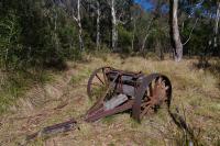
From the carpark it is a 1.1 Km walk to an old Timber Jinker on the Mount Mathieson trail.
Spicers Gap makes a great day out or weekend destination and with such awesome panoramic views and spectacular scenery is well worth the effort to get there.
.Shane Gerrish
This Highway was not the original route to the Darling Downs though, the earlier route was discovered by stockman Henry Alphen in 1847 and the subsequent road up through Spicer Gap was built in the late 1850’s, its here we get the chance to get the wheels a little dirty and take in some of the serenity and fantastic scenery of the area.
National Parks have closed the central portion of the road to vehicles but access is still available to both ends and you can walk the closed section.
A day use area and Campground is available opposite the site of the old tavern.
To access the Spicers Gap section head east on the highway from Aratula for 5 Km and turn left then after a further 5.7 Km turn right and follow this road for 3 Km until the road turns to gravel, it is suitable for all vehicle types although the steep gravel section could be a problem in a front wheel drive and 4wd would be needed in wet weather.

2.6 Km later an unmarked lookout on the right is worth stopping for a look as it affords a view over grasstrees to the hills in the distance.

The park boundary comes up a short time later and 1.4 Kms after the lookout we turn left into the picnic area just after the campground entrance.
Although Fires are not allowed in the campground they supply wood fired BBQ’s in the picnic area next door, seems a little strange!
A disabled access toilet sits between the two.
A short walk leads to the memorial of the 13 unmarked graves in the unmarked cemetery, the writing seems to have been done by what appears to be carpet tacks or similar imbedded in the concrete.


We noticed something white on a hollow tree not far away but upon investigation turned out to be a sign saying “no Geocacheing allowed” … I think I would prefer to “not” see a Geocache hidden in the hollow of a tree than a big national parks sign saying this is where it used to be until it was removed.


Across the road an orchard has been built on the site of the old tavern but we could not see any old relics from the roadway so we had a look around the campground instead, it does not look well used so should be a fairly quiet and tranquil spot to make camp although the usual National Park bollards make it hard for vehicle based camping.

Mount Mathieson is spelt three different ways by National Parks on signs and pamphlets , Mount Matherson, Mount Matheson and Mount Mathieson but as there is a Mount Matheson in Nightcap national park we can probably discount that one.
The Chief Commissioner of railways was a man named John Mathieson and the nearby peak was apparently named after him so that is the most likely spelling.
The Mount Mathieson Walking track heads past the orchard opposite the campground finishing at the western end of the closed section of road.
The eastern end of the closed road at Governors chair is only 2 Kms away by gravel road.
We drove on crossing a deep puddle and stopped for a look at Moss’s Well, a round concrete ring full of fresh water supplied by a nearby spring.


We continued on and it wasn’t long before we reached the carpark and picnic table at Governors Chair where we walked the 150 metres up the stairs to the lookout with spectacular views over the surrounding countryside.
“Governors Rock” as it was first called was named after Governor-General Sir Charles Fitzroy in 1854, perhaps the U shaped rock inspired the name change to Governors Chair?


The 1.6 Km closed off section of road begins across the other side of the carpark and has interpretive signs dotted along the way explaining some of the roads construction methods such as Corduroy and Stone Pitching.

The diversionary embankments used to divert water across the road probably get their name from the term “Whoaboy” used by the bullock drivers when approaching these banks.
After our walk we decided to explore the western end of the Spicers Gap road and made our way back to the Cunningham Highway where we turned left and drove up the range over Cunninghams Gap, we passed the Pacific Petroleum servo and about 1Km later turned left off the highway on an unmarked road that is very hard to spot so keep an eye on your mirror and your speed down as the turn is just after a bend and traffic is all high speed on a downhill highway.

This section of road is suitable for 4WD only but high clearance soft roaders should be OK in dry conditions.
The road passes through private property for about 7Kms and crosses a couple of swampy sections and a creek on its way, just veer right at the Y intersection and go straight ahead at the cross road to get to the carpark at the western end of the closed section of road.


From the carpark it is a 1.1 Km walk to an old Timber Jinker on the Mount Mathieson trail.

Spicers Gap makes a great day out or weekend destination and with such awesome panoramic views and spectacular scenery is well worth the effort to get there.
.Shane Gerrish
Saturday, July 18, 2009
Sunshine Coast Weekend
A few Photographers had planned an early pre dawn photoshoot at Point Cartright on Sunday Morning but since i'm not good at driving before dawn i thought i'd go up a little early.
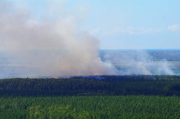
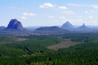
Leaving home on Saturday morning on a cool clear crisp day i thought i'd take advantage of the lack of haze and stop in at Wild Horse Mountain to photograph the Glass House Mountains ... just my luck, there was a fire and guess where the smoke was blowing to :roll:
i cleaned it up in photoshop as much as i could.
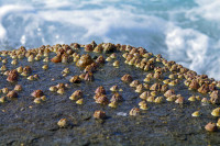
next stop Shelley Beach to scoff my lunch and have a bit of a wander around in.
its quite interesting wandering around the rocks and rockpools.

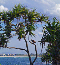
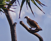
speaking of birds...
I tried to sneak up on this bird but all i had was the 100mm macro and it took off as soon as i got to within 50 metres of it
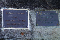
spotted these two interesting Plaques just to the south.
some people were just content to just kick back and enjoy the view...
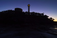
I don't think i've ever seen a pic of the SS Dickey in broad daylights so i headed down there to grab one...


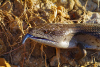
Out at Point Cartright i found a couple of Blue Tongue Lizards ...

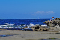
and a fishergirl ...

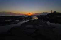
the sun was setting over the harbour ...

as twilight fell the clouds lit up ...

Then as i was walking back to the car i took one last pic ... and got swamped by a rouge wave ... head to toe, camera, lens, tripod ... the lot!!
had to strip off and run the heater in the car to dry everything out
Lucky its a Pentax K7 and its weather proof
that whitish blur in a semi circle across the bottom of the pic is the wave going past ... i was trying to hold the camera and tripod still so i'd at least get the pic
----------------------------------------------------------------------------
----------------------------------------------------------------------------
I was awoken at about 4:15 am by dozens of boats leaving the harbour ... complete with foghorns , after meeting with the rest of the crew, I headed out on the breakwater to get a shot of the sunrise ...
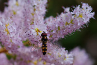
We then headed over to Mooloolaba for brekky before loading the non 4Wdrivers into our 4WD's and driving to Lake MacDonald for some macro shots and to meet up with some of the others who had skipped the early morning part.
These Hover Fly's are tiny ... about half the size of a normal bee... and the shot is quite a big crop ...
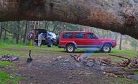
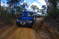
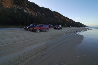
With all the participants now with us we headed out to Cooloola way and slipped into the forest for a bit of 4WDrings to the "Secret Spot".
While the others took photo's i walked down through the next few bogholes to check the depth and with everything looking OK we pushed on through to dry ground...
James was having a test run with his new Middy ...
Mark had his new Pajero along ...
We exited the forest and headed to Rainbow beach for a late lunch.
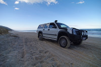
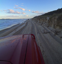
After lunch we backtracked to the Freshwater track and made our way to the beach.
Doug had his new Rodeo out for the run...
We stopped at Red Canyon for a look...
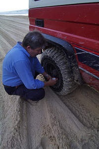
It was getting real close to high tide and James was having overheating problems in the thick soft sand so we stopped on a wide patch to lets some more air out...
Mark helps out...
there was not much room left by the time we got to the end but i only had to drive through salt water in the wheel track once.
The Sun was setting as we aired up and took the ferry across ...
was a great day out and a good test for Mavered.
Thanks to all the rest for a good time
then it was just a matter of headed back to the lights of the Gold Coast ...
Leaving home on Saturday morning on a cool clear crisp day i thought i'd take advantage of the lack of haze and stop in at Wild Horse Mountain to photograph the Glass House Mountains ... just my luck, there was a fire and guess where the smoke was blowing to :roll:

i cleaned it up in photoshop as much as i could.

next stop Shelley Beach to scoff my lunch and have a bit of a wander around in.
its quite interesting wandering around the rocks and rockpools.


speaking of birds...
I tried to sneak up on this bird but all i had was the 100mm macro and it took off as soon as i got to within 50 metres of it


spotted these two interesting Plaques just to the south.

some people were just content to just kick back and enjoy the view...

I don't think i've ever seen a pic of the SS Dickey in broad daylights so i headed down there to grab one...


Out at Point Cartright i found a couple of Blue Tongue Lizards ...


and a fishergirl ...

the sun was setting over the harbour ...


as twilight fell the clouds lit up ...

Then as i was walking back to the car i took one last pic ... and got swamped by a rouge wave ... head to toe, camera, lens, tripod ... the lot!!
had to strip off and run the heater in the car to dry everything out
Lucky its a Pentax K7 and its weather proof
that whitish blur in a semi circle across the bottom of the pic is the wave going past ... i was trying to hold the camera and tripod still so i'd at least get the pic

----------------------------------------------------------------------------
----------------------------------------------------------------------------
I was awoken at about 4:15 am by dozens of boats leaving the harbour ... complete with foghorns , after meeting with the rest of the crew, I headed out on the breakwater to get a shot of the sunrise ...

We then headed over to Mooloolaba for brekky before loading the non 4Wdrivers into our 4WD's and driving to Lake MacDonald for some macro shots and to meet up with some of the others who had skipped the early morning part.

These Hover Fly's are tiny ... about half the size of a normal bee... and the shot is quite a big crop ...

With all the participants now with us we headed out to Cooloola way and slipped into the forest for a bit of 4WDrings to the "Secret Spot".
While the others took photo's i walked down through the next few bogholes to check the depth and with everything looking OK we pushed on through to dry ground...
James was having a test run with his new Middy ...

Mark had his new Pajero along ...

We exited the forest and headed to Rainbow beach for a late lunch.
After lunch we backtracked to the Freshwater track and made our way to the beach.
Doug had his new Rodeo out for the run...

We stopped at Red Canyon for a look...

It was getting real close to high tide and James was having overheating problems in the thick soft sand so we stopped on a wide patch to lets some more air out...
Mark helps out...


there was not much room left by the time we got to the end but i only had to drive through salt water in the wheel track once.

The Sun was setting as we aired up and took the ferry across ...
was a great day out and a good test for Mavered.
Thanks to all the rest for a good time
then it was just a matter of headed back to the lights of the Gold Coast ...

Subscribe to:
Posts (Atom)
